Many of you know that I enjoy walking and a six or seven mile stroll by the Severn River from Tewkesbury to Upton sounded like a nice way to spend a morning. It did not quite turn out that way but read on.

I arrived down at the bus stop in time to catch the 8:39 bus which you can see getting ready to turn onto the main road from a side street.

The fare to Tewkesbury was three pounds and I was the only passenger. According to the bus driver, this was typical of the early morning run.

Tewkesbury looked much the same as last time.


Old pub by the river Avon.

The Avon splits into two at Tewkesbury but this part seems to be the busier.


The other part.

I strolled beside the busy road. Fortunately there was a foot path so I could stop to take this photo of a stately home on the nearby hill.

The water treatment plant.

An old house in the treatment plant grounds. I presume it now has offices.

The Mythe bridge over the Severn that was designed by Thomas Telford.

Probably a building for collecting tolls at one time.

Looking down stream.

Up stream where I would walk on the left bank. Somehow I forgot to look back and get a photo of the bridge.

House on the western side of the river.

As I was taking this photo of the sign, the owner of the house came along and asked if he could help me. He was pleased when he found out I was doing the walk. He was retired and trained rowers on the river. They usually would row all the way to Upton and back.
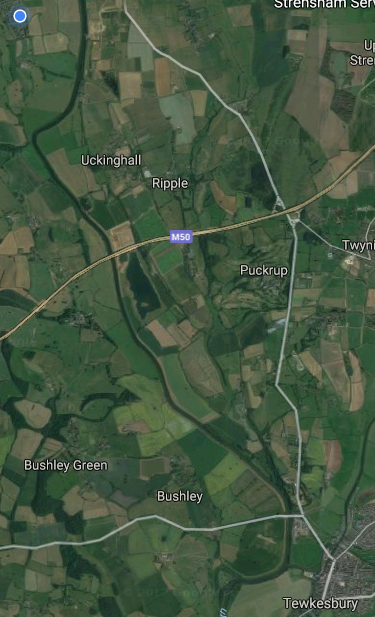
So here is the Tewkesbury to Upton map with the Severn River winding its way up the western side of the map. The M50 motorway is roughly half way.


So I toddled along this path feeling really good.


Crops growing in the field.

Cows ahead!
Some of you might remember that I am following a blog of a woman who is walking around the UK. She is very scared of cows which have been known to trample people to death, particularly at this time of year when they have calves. A few days ago it happened to some man near Brighton.

My initial idea was to go through the gate on the right and then try to edge by using the electrified fence on the right as a barrier. Unfortunately the fence was positioned right by the bank so there was no room to walk on the protected side by the river.

Then some of the cows wandered over and they did not look happy. The solution was another gate about 50 yards to the left. All the cows had moved to the corner where I was standing. I quickly walked to that other gate and then ran about fifty yards until I was well past them. The unfriendly cows were trapped in the corner and could not get past the rest of the herd bunched in the corner. Yes, I am a little bit smarter than the average cow.

They were presumably glad to see me departing.


It was really pleasant strolling along looking at the scenery.

The tape marking the electrified fence.

A canal boat motored past. If you want a week's relaxing holiday, this is the thing to do.

Another stile to climb over.

Just harvested.

Along with the swans, there were quite a few fishermen on the other bank. I did not notice any on my side of the river.


A handy bridge over a tiny creek.

I forced my way through the high growth to the gate.

I was greeted by this on the other side so I forced my way though.

When I emerged I noticed when I looked back that there was a simpler path.

The high vegetation continued so it was quite a slog now.


Occasionally you could see where somebody had forced their way though sometime in the past.

Another stile with the M50 Motorway bridge over the Severn in the distance. I had been walking about an hour. Somehow, I missed seeing the path on the other side of the stile that continued by the river and this became a problem.

The path now appeared to head inland a little beside this playing field so I followed it instead of checking on my phone GPS.

Shooting? Hearing no guns, I continued. There was no way I was going back to face that herd of unfriendly cows.


There was some sort of platform and the next photo shows the device on the top was used for throwing clay pigeons into the air. That explained the shooting sign.

Clay pigeons.

Through another stile. No wonder I thought I was on the correct path.

And then I noticed that there was a big gully in the way on the other side of the shooting tower. I looked at the map on my phone but for some unknown reason, the trail for this short section did not load.

In addition, some more cows were skulking about right where I thought I should walk and they all got up to check me out.

I thought about crossing this fence but eventually I decided to try to cross the gully. However what I thought to be a dry bottom to the gully turned out to be three feet of water. I fell over and was soaked but managed to clamber out. Everything up to my neck was wet. The camera stopped working.

You can see the route I should have taken on the right hand side. There was even a bridge to cross Longdon Brook. I fell in roughly about the k at the top of the photo. I finished up walking over to the road at the left.

Having crossed the little bridge over the brook I continued on using the central path and eventually met up with the path by the river. This path was severely overgrown so I had to force my way through lots of thorns and what I suspect were stinging nettles which are stinging as I type. On a scale of 0 to 10 the pain is about 1 where zero is low. It's more of an irritant.
Eventually I made it back to the house where I demolished a whole bottle of cold cider. I was more tired than I had expected to be, largely because of the long undergrowth that makes walking difficult. The walk took about 2 1/2 hours which is about what I expected.
Hopefully my camera and phone will dry out. I am using the 'put them in an airtight container with rice to draw out the moisture' trick, but I am not very hopeful.
So anyhow I am still in one piece and only the gadgets have suffered along with my pride. I had been thinking of doing the Severn Way from Worcester to Upton but I suspect the track will be just as overgrown so that walk has been crossed off my list.
My husband and I walked this route but in the opposite direction last week. We had been holidaying in the area walking the Malvern Hills and fancied a level walk. Sadly, we had mucth the same experience, encountering heavily overgrown fields and stiles, with no discernable path for much of the route. There were bullocks in the same field as you found them, extremely boisterous and chasing up and down the field. Unfortunately as we were approaching from the opposite direction we had no option but to proceed at a fast pace, hugging the electrified fence. I was brandishing my pointed walking pole to keep them away and my husband a stick he wad picked up. Even so, some overtook us and we almost didn't get out. Very frightening. We were so exhausted by the effort of struggling through the long grass, brambles and nettles that we ordered a taxi to get back to Upton.
ReplyDeleteWell done. We have a caravan on the other side of the river. We can walk as far as ripple without too much trouble. I'm not sure how bad the path gets the rest of the way. Michelle
ReplyDelete